
AgentsAutonomy & tool use
Maya site flagged by 48 AI agents in NASA lidar had already been mapped in a 2025 study
A Google researcher's multi-agent workflow flagged a hilltop Maya complex he called unmapped. Archaeologists showed it appeared in a 2025 regional lidar study. The episode points to checking prior work, not spotting features, as the weak link for AI-assisted discovery.
From the The Verge · AI article of November 12, 2026 and cited sources: The complex Pietro Miotti's agents flagged, a plaza, an oval pyramid of roughly 8–12 m and a possible reservoir, was already covered by a 2025 study of about 95,000 km² of the Central Maya Lowlands. [1] [2] [6]
SOURCES[1] No, AI agents did not discover a previously unknown Maya… theverge.com[2] Tulane: Ancient Maya population may have topped 16 million news.tulane.edu[6] Pietro Miotti: My AI Agents (Re)discovered a Maya Site in… pietromiotti.com
 AT Pulse research deskPublished · Updated · 5 min read · AI-assisted analysis
AI-assisted, not human-edited. Methodology Corrections Who owns this site
- What happened
- The complex Pietro Miotti's agents flagged, a plaza, an oval pyramid of roughly 8–12 m and a possible reservoir, was already covered by a 2025 study of about 95,000 km² of the Central Maya Lowlands. [1] [2] [6]
- Original source
- The Verge · AI article, independent perspective
- Brief by
- AT Pulse research desk AI-assisted; publisher and contact on the desk page
- When
- November 12, 2026 article published
- Covered
- Nov 13 edition
- Evidence
- 8 sources across 8 sites
- 1No, AI agents did not discover a previously unknown Maya…theverge.com
- 2Tulane: Ancient Maya population may have topped 16 millionnews.tulane.edu
- 3DEV Community: AI Agents Found a Maya Site in 72 Hours.…dev.to
- 4Fathom: AI Agents Flag Possible Maya Site In NASA Lidar Datafathom.news
- 5Pietro Miotti on Xx.com
- 6Pietro Miotti: My AI Agents (Re)discovered a Maya Site in…pietromiotti.com
RisingHow it’s measured
Hacker News · 11 likes · 1 comment
Reach blends public engagement (views, likes, comments, shares, stars) from the platforms where the story or its original source lives: YouTube, Hacker News, GitHub, Substack and similar. A video and the article written from its transcript share one score, taken from the video. Platforms with no data are left out rather than counted as zero, and the age of a story never lowers its score.
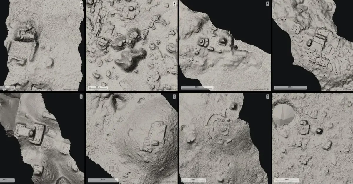
The complex Pietro Miotti's agents flagged, a plaza, an oval pyramid of roughly 8–12 m and a possible reservoir, was already covered by a 2025 study of about 95,000 km² of the Central Maya Lowlands. His blog now calls the result a rediscovery and cites that work. [1] [2] [6]
Miotti read a reply from Mexico's archaeology institute, INAH, saying no site was registered at the location as a sign of novelty. Coauthor Ivan Šprajc called that insufficient evidence, because the registry is incomplete. [1] [4]
The workflow used no trained detector. Agents built on general-purpose models reviewed lidar rendered as images, following a written guide to rule out hills, sinkholes and roads, and then rechecked candidates against the raw point cloud. Its weak step was searching prior work, because published sites appear as paper figures rather than coordinates. [1] [3] [4]
Archaeologists raised further concerns: publicizing locations could invite looting, a surge of AI-generated claims could burden experts, local communities often already know these sites, and the real constraint is funding for excavation and mapping. [1]
low-cost agents surfaced real features, but they missed published work. Implication: in any field, a database miss is not proof of novelty. Expert review and figure-level literature search should come before public claims.
Executive brief
The "unmapped" Maya site that Google researcher Pietro Miotti's 48 AI agents flagged in NASA lidar data had already been mapped. It appeared in a 2025 Journal of Archaeological Science: Reports paper. One of that paper's coauthors, Ivan Šprajc, spoke to The Verge. Miotti treated a reply from Mexico's archaeology institute (INAH), saying it had no registered site at that spot, as a sign the site was new. Archaeologists say having no registry entry doesn't mean nobody has found or mapped the site. Miotti has since retitled his post as a "(Re)discovery." The agent workflow did spot real features. Its failure was the check against existing research.
What changed and event timeline
Site already published
A paper by Estrada-Belli, Canuto, Šprajc and Fernandez-Diaz mapped settlement across 95,000 km² of the Central Maya Lowlands. Part of the lidar came from NASA Goddard ().
72-hour sprint
Miotti went from an idea he had while traveling in Peru to an INAH reply in about three days. The agents reviewed roughly 1,200 km² of lidar (;).
- Early Nov 2026
Public claim
Miotti posted that his agents had found an "unmapped Maya site" (). Fathom's write-up, published Nov. 11, included no independent expert comment ().
Prior work credited
After archaeologists objected, the blog was updated to cite Estrada-Belli et al. 2025 (;).
Expert pushback reported
The Verge quoted Sarah Parcak, Elizabeth Graham and Šprajc. All three questioned the "discovery" framing and the reliance on INAH's registry ().
Capabilities and access
- Setup: 48 agents using Gemini, ChatGPT, Claude and Grok. No exact model versions are disclosed (Miotti blog).
- The blog doesn't name the specific dataset (Fathom).
- Resources: Miotti says it was a personal side project that used no Google compute (The Verge).
Read the full section
- Setup: 48 agents using Gemini, ChatGPT, Claude and Grok. No exact model versions are disclosed (Miotti blog).
- Data: free public NASA lidar. The blog doesn't name the specific dataset (Fathom).
- Resources: Miotti says it was a personal side project that used no Google compute (The Verge).
- What was flagged: a hilltop complex with a plaza, an oval pyramid 8–12 m tall, a raised courtyard and a possible reservoir. Coordinates are withheld (Miotti blog).
Technical analysis for researchers and developers
- No trained detector: lidar strips were turned into images, and the agents looked at them while following a written guide meant to exclude hills, sinkholes and roads (DEV Community).
- Second pass: candidates were rechecked against the raw point cloud to confirm ground features beneath 10–17 m of canopy (Fathom).
- Weak point: checking for prior work.
Read the full section
- No trained detector: lidar strips were turned into images, and the agents looked at them while following a written guide meant to exclude hills, sinkholes and roads (DEV Community).
- Second pass: candidates were rechecked against the raw point cloud to confirm ground features beneath 10–17 m of canopy (Fathom).
- Weak point: checking for prior work. Archaeologists don't publish site coordinates, so the only way to check is to compare images with figures in papers, which Miotti says agents handle poorly (The Verge).
- Not reproducible yet: no precision or recall figures, false-positive rate, prompts or code are published.
Claims and evidence
- "Unmapped site": contradicted by the 2025 paper (Tulane; Miotti blog).
- INAH "no registered site": the quote is reported only by Miotti and his blog (Fathom). Šprajc says INAH lacks some information, so its reply is "not sufficient" evidence (The Verge).
- Mapping quality: Graham credited Miotti with a decent job of mapping the mounds (The Verge). This is an informal opinion, not an evaluation.
Read the full section
- "Unmapped site": contradicted by the 2025 paper (Tulane; Miotti blog).
- INAH "no registered site": the quote is reported only by Miotti and his blog (Fathom). Šprajc says INAH lacks some information, so its reply is "not sufficient" evidence (The Verge).
- Mapping quality: Graham credited Miotti with a decent job of mapping the mounds (The Verge). This is an informal opinion, not an evaluation.
- Archaeologists interested in the workflow: Miotti is the only source for this.
- No fieldwork: no one has verified the site on the ground (Fathom).
Context and prior work
Archaeologists in this region have used lidar for years. Šprajc's team reported Ocomtún in Campeche from airborne laser scanning (SciELO). Another Campeche study argued the lidar shows a densely settled landscape that is "running out of empty space" (Antiquity). The 2025 regional study estimated 9.5–16 million Late Classic inhabitants (Tulane).
Read the full section
Archaeologists in this region have used lidar for years. Šprajc's team reported Ocomtún in Campeche from airborne laser scanning (SciELO). Another Campeche study argued the lidar shows a densely settled landscape that is "running out of empty space" (Antiquity). The 2025 regional study estimated 9.5–16 million Late Classic inhabitants (Tulane). The Verge connects this episode to wider complaints that AI-produced scientific results often don't engage with existing literature.
Limitations, safety and contested findings
- Looting risk: publicizing site locations could attract looters. Šprajc raised this, and Miotti withheld coordinates (The Verge; Miotti blog).
- Expert workload: Šprajc worries about a flood of emails from AI "discoverers." He received another one the day he spoke to The Verge (The Verge).
- "Discovery" framing: Graham says local communities often already know these sites, and many unexplored sites were found on foot (The Verge).
Read the full section
- Looting risk: publicizing site locations could attract looters. Šprajc raised this, and Miotti withheld coordinates (The Verge; Miotti blog).
- Expert workload: Šprajc worries about a flood of emails from AI "discoverers." He received another one the day he spoke to The Verge (The Verge).
- "Discovery" framing: Graham says local communities often already know these sites, and many unexplored sites were found on foot (The Verge).
- Funding, not detection, is the bottleneck: Graham says the real constraint is money for excavation and mapping (The Verge).
Business and practitioner implications
- Cheap screening is real: off-the-shelf multi-agent vision can screen about 1,200 km² overnight with no custom model.
- Prior-work search is the gap: when the evidence sits in paper figures rather than databases, agents need image-to-figure retrieval, and builders should plan for that.
- Check before announcing: don't treat a database miss as proof of novelty.
Read the full section
- Cheap screening is real: off-the-shelf multi-agent vision can screen about 1,200 km² overnight with no custom model. The scarce part is domain validation, not detection.
- Prior-work search is the gap: when the evidence sits in paper figures rather than databases, agents need image-to-figure retrieval, and builders should plan for that.
- Check before announcing: don't treat a database miss as proof of novelty. Have domain experts review results before any public claim, especially where the data is sensitive, as site locations are here.
- Better positioning: a tool that helps experts triage their own survey data is a more credible pitch than "AI discovers."
The source trail.
Sources (8)
No, AI agents did not discover a previously unknown Maya site
Article text retrieved; extracted text may omit tables or interactive elements.
theverge.com